Boundary disputes are one of the most common sources of conflict between property owners across the UK. Whether it's a fence that's been erected in the wrong place, confusion over where your garden ends, or a neighbor claiming land you thought was yours, these disputes can escalate quickly and become expensive legal battles. Fortunately, My Topographic Surveyor UK has helped hundreds of property owners resolve boundary issues using professional boundary surveys conducted by experienced land surveyors.
In this comprehensive guide, we'll explain how boundary disputes arise, why they're so common, and most importantly, how an accurate boundary survey from RICS-accredited surveyors can provide the definitive evidence needed to settle disagreements peacefully or through legal channels if necessary.
Understanding Property Boundaries in the UK
Property boundaries in the UK are often less clear-cut than people assume. Unlike some countries where boundaries are precisely marked with permanent monuments, UK property boundaries are defined by legal documents that reference physical features which may have changed or disappeared over time.
The Land Registry holds title plans for most properties, but these plans typically show boundaries as "general boundaries" rather than exact legal boundaries. This means the red line on your Land Registry plan indicates the approximate position of your boundary, not its precise legal location. This fundamental misunderstanding is the root cause of many boundary disputes.
Common Causes of Boundary Disputes
Our experienced surveyors encounter these typical scenarios regularly:
- Historic fence lines: Fences that were erected years or decades ago may not follow the legal boundary. When old fences are replaced, disputes often emerge about the correct position.
- Garden encroachment: One property owner has gradually extended their garden into neighboring land, perhaps by moving plants, sheds, or creating pathways.
- Unclear title deeds: Old property deeds may reference features that no longer exist ("from the old oak tree to the stream") making boundary determination difficult.
- Development work: Building extensions or installing new boundary treatments can bring attention to previously ignored boundary ambiguities.
- Change of ownership: New property owners may interpret boundaries differently than previous occupants, leading to conflict with established neighbors.
How Professional Boundary Surveys Work
A professional boundary survey from My Topographic Surveyor UK involves far more than just measuring fence lines. Our experienced land surveyors use highly specialised survey equipment including total stations and laser technology to determine accurate property boundaries based on legal documents and physical evidence.
The Boundary Survey Process
Step 1: Document Research
Before visiting your property, our surveyors obtain and review all relevant legal documents including Land Registry title plans, historic deeds, Ordnance Survey maps, and any previous survey data. This research identifies what the legal boundary should be according to official records.
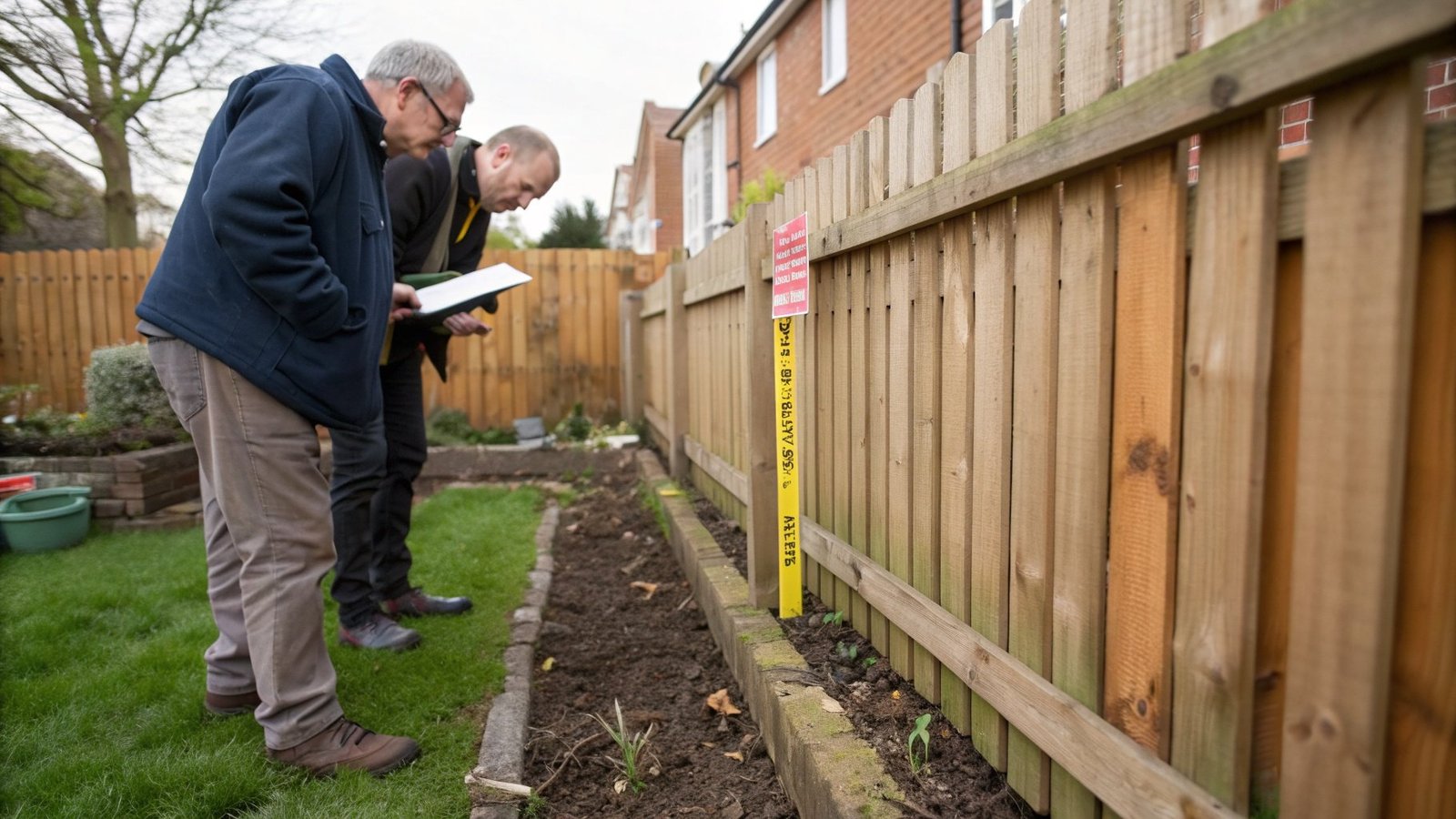
Step 2: Site Investigation
Our experienced surveyors visit the property with professional survey equipment. We measure existing fence lines, walls, hedges, and other physical boundaries using total stations that provide millimeter accuracy. We also photograph the boundary and note the condition of boundary features.
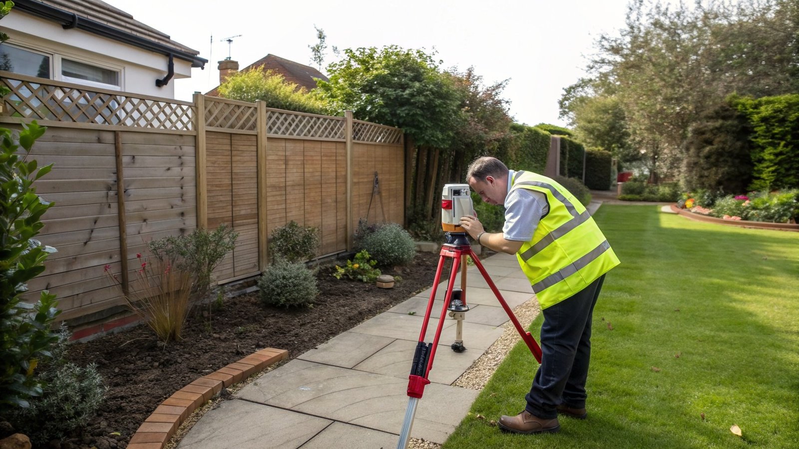
Step 3: Precise Measurement
Using laser equipment and GPS technology, we establish the position of physical boundaries relative to known reference points. This allows us to create an accurate map showing where boundaries actually are versus where they legally should be according to Land Registry documents.
Step 4: Analysis and Reporting
Our experienced land surveyors analyze the survey data, comparing physical boundaries with legal descriptions. We produce detailed survey drawings that clearly show any discrepancies between the legal boundary and physical features.
What a Boundary Survey Report Includes
When you commission a boundary survey from My Topographic Surveyor UK, you receive a comprehensive report that provides compelling evidence for resolving boundary disputes:
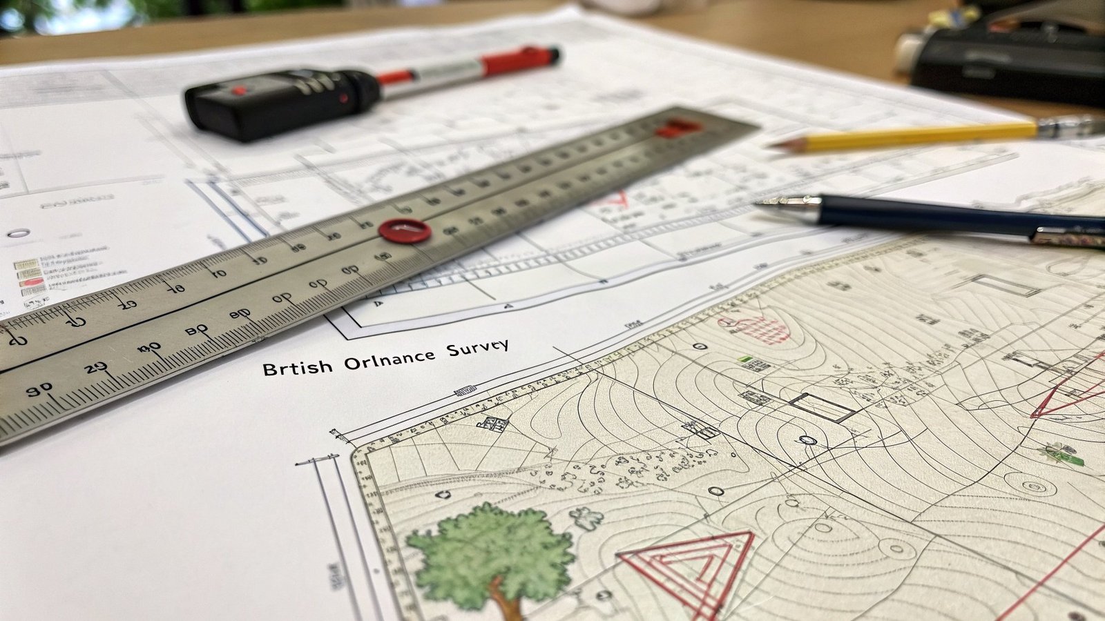
- Scaled survey drawings: Professional CAD drawings showing your property, neighboring properties, and all boundary features with precise measurements.
- Ordnance Survey coordinates: Your boundaries referenced to the national grid, allowing exact comparison with Land Registry plans.
- Measured dimensions: Accurate distances between boundary points, fence posts, walls, and property corners.
- Photographic evidence: Images of the disputed boundary showing its current condition and position.
- Expert analysis: Written commentary from our RICS-accredited surveyors explaining how physical boundaries relate to legal boundaries.
- Overlay comparisons: Survey data overlaid on Land Registry plans to show discrepancies visually.
Resolving Disputes: Options Available
Once you have an accurate boundary survey, several resolution paths become available:
Negotiated Settlement
In many cases, clear survey evidence from experienced surveyors helps neighbors reach agreement without legal action. When both parties can see exactly where the legal boundary lies, disputes often resolve quickly. Our boundary surveys have helped hundreds of property owners find amicable solutions, sometimes resulting in boundary agreements that are then registered with Land Registry.
Land Registry Determination
For more complex boundary issues, you can apply to Land Registry for a "determined boundary." This is an official determination of the exact boundary line, which is then recorded on the title plan. Our experienced land surveyors frequently provide survey data to support Land Registry applications, and our survey drawings meet the survey specifications required by Land Registry.
Legal Proceedings
If negotiation fails, boundary disputes may proceed to court. Professional boundary surveys from RICS-accredited surveyors provide crucial expert evidence. Our experienced surveyors have provided expert witness reports and court testimony in numerous boundary dispute cases across the UK. The accurate topographic data from our surveys, combined with our professional accreditation, carries significant weight in legal proceedings.
The Legal Framework
UK property law provides several mechanisms for resolving boundary disputes. Understanding these helps you appreciate why professional survey data is so valuable:
Adverse Possession
If someone has occupied land beyond the legal boundary for a continuous period (usually 10-12 years), they may claim legal ownership through adverse possession. A boundary survey can establish whether adverse possession criteria might apply and provide the accurate survey data needed for Land Registry applications.
Prescriptive Easements
Long-term use of land for access or other purposes can create legal rights even if it crosses someone else's property. Our topographical surveys document access routes and land use patterns that may be relevant to easement claims.
Party Wall Act
For boundaries marked by walls shared between properties, the Party Wall Act provides specific procedures. Our measured surveys provide the precise dimensions needed for Party Wall agreements and can identify encroachments or structural issues.
Preventing Future Disputes
Once a boundary dispute is resolved, consider these steps to prevent future problems:
- Register the agreement: If you've reached a boundary agreement with neighbors, register it with Land Registry to create a permanent record.
- Update title plans: Use your boundary survey to apply for a determined boundary at Land Registry, making the exact boundary legally clear.
- Mark boundaries clearly: Install boundary markers at key points, positioned according to your boundary survey.
- Keep survey records: Store your boundary survey drawings safely and provide copies to future purchasers when selling.
- Maintain boundary features: Keep fences, walls, and hedges in good condition and in the correct position as shown on survey drawings.
Cost Considerations
Property owners sometimes hesitate to commission boundary surveys due to land survey cost concerns. However, compared to the expense of protracted legal disputes, the cost of a professional boundary survey is minimal. A typical boundary survey for a residential property costs between £400-£900, while boundary dispute legal proceedings can easily exceed £10,000-£20,000.
My Topographic Surveyor UK provides free quotes for boundary surveys with transparent pricing. The survey cost depends on the property size, complexity of the boundary issue, and level of detail required. Our experienced surveyors assess your specific situation and provide an accurate quote before starting any work.
Why Choose RICS-Accredited Surveyors
When commissioning a boundary survey for dispute resolution, professional accreditation matters. My Topographic Surveyor UK's surveyors are accredited under RICS (Royal Institution of Chartered Surveyors), CIOB, and RPSA. This accreditation ensures:
- Technical competence in surveying and boundary determination
- Professional indemnity insurance covering survey work
- Adherence to professional standards and ethics
- Credibility as expert witnesses if disputes reach court
- Use of calibrated, highly specialised survey equipment
- Continuing professional development and current knowledge
Real-World Examples
Our experienced land surveyors have resolved countless boundary disputes across the UK. Here are anonymized examples:
Case 1: Garden Fence Dispute in Surrey
Two neighbors disagreed about a garden fence position by approximately 1.5 meters. Our boundary survey revealed that the fence followed the historical boundary, not the legal boundary shown in title deeds. The survey data supported a negotiated settlement where the fence was relocated to the correct position, with one owner compensating the other for lost land.
Case 2: Driveway Encroachment in Manchester
A property owner discovered their neighbor's driveway extended 0.8 meters onto their land. Our topographic survey provided the evidence needed for a Land Registry determination application. The boundary was officially determined, and the driveway owner agreed to remove the encroachment.
Case 3: Commercial Property Boundary in Birmingham
A complex dispute between two commercial properties involved multiple boundary issues. Our comprehensive boundary survey, including detailed survey drawings and expert analysis, formed the basis of a court settlement that saved both parties significant legal costs compared to a full trial.
Conclusion
Property boundary disputes can be stressful and expensive, but they don't have to escalate into costly legal battles. A professional boundary survey from experienced land surveyors provides the accurate topographic data needed to resolve disputes based on facts rather than assumptions.
My Topographic Surveyor UK's RICS-accredited surveyors have the expertise, professional survey equipment, and legal knowledge to support boundary dispute resolution across the whole of the UK. Whether you need evidence for negotiation, a Land Registry application, or court proceedings, our boundary surveys deliver the level of detail and accuracy required.
Don't let a boundary dispute damage your relationship with neighbors or result in expensive litigation. Contact My Topographic Surveyor UK today for a free quote on a professional boundary survey. Our experienced surveyors are ready to help resolve your boundary issues quickly and professionally.
FAQs: Boundary Disputes and Surveys
How accurate are boundary surveys for resolving disputes?
My Topographic Surveyor UK uses professional-grade total stations and laser equipment that provide millimeter-level accuracy. Our RICS-accredited surveyors measure boundaries to survey specifications that are legally acceptable for Land Registry determinations and court proceedings. Typical accuracy is ±5-10mm for residential boundaries, which is more than sufficient to resolve disputes about fence positions, encroachments, or property lines.
How long does a boundary survey take?
The site visit for a residential boundary survey typically takes 2-4 hours depending on property size and boundary complexity. Our experienced surveyors then process the survey data and produce detailed CAD drawings within 5-10 working days. For urgent disputes requiring faster turnaround, we offer expedited services with delivery within 3-5 working days for an additional fee.
Will a boundary survey definitively resolve my dispute?
A professional boundary survey provides objective evidence about where the legal boundary should be according to title deeds and Land Registry plans. In approximately 70-80% of cases, clear survey evidence from experienced RICS surveyors helps neighbors reach agreement without further action. For complex disputes, the survey forms essential evidence for Land Registry determinations or court proceedings.
Can I do my own boundary survey to save money?
While you can measure your boundaries yourself, DIY surveys lack the accuracy, professional equipment, legal knowledge, and credibility needed to resolve disputes. Land Registry and courts require survey data from qualified, accredited surveyors. Attempting DIY surveys often prolongs disputes and may ultimately prove more expensive than commissioning professional surveyors from the outset. Our boundary survey costs (£400-£900) are minimal compared to potential legal costs.
What if my neighbor refuses to accept the boundary survey results?
If your neighbor disagrees with survey findings, several options remain available. First, our experienced surveyors can explain the survey methodology and evidence directly to both parties. Second, you can apply to Land Registry for an official "determined boundary" using our survey data. Third, if necessary, disputes can proceed to court where our RICS-accredited surveyors can provide expert witness testimony. Survey evidence from professional land surveyors carries significant legal weight.
Do I need my neighbor's permission to commission a boundary survey?
No, you don't need your neighbor's permission to survey your own property boundaries. However, if survey work requires accessing neighboring land for measurements, professional courtesy suggests informing neighbors. Our experienced surveyors handle neighbor relations tactfully and explain that surveys benefit both parties by establishing facts. In most cases, neighbors appreciate professional survey data resolving uncertainty.
How much does a boundary survey cost for dispute resolution?
Boundary survey costs for residential properties typically range from £400-£900 depending on property size, boundary length, and survey complexity. More complex disputes involving detailed historical research, multiple boundary issues, or expert witness services cost £1,200-£2,500. My Topographic Surveyor UK provides free quotes and transparent pricing. These costs are far less than legal proceedings, which commonly exceed £10,000-£20,000.
Can boundary surveys help with adverse possession claims?
Yes, boundary surveys are essential for adverse possession claims. Our topographic surveys document the extent of land occupation, establish how much land extends beyond legal boundaries, and provide the accurate survey drawings required for Land Registry adverse possession applications. Survey data must show continuous occupation of land beyond the legal boundary for the required period (typically 10-12 years for registered land).
What happens if the survey shows I've built on my neighbor's land?
If our boundary survey reveals you've encroached onto neighboring land, several resolution options exist: negotiate compensation for the encroachment, purchase the land strip from your neighbor, apply for adverse possession if you've occupied the land long enough, or in some cases, remove or relocate the encroaching structure. Our experienced land surveyors provide guidance on options based on your specific circumstances and local precedents.
Are boundary surveys different from topographic surveys?
Yes, boundary surveys focus specifically on property lines and boundaries, using title deeds, Land Registry plans, and historical documents to establish legal boundaries. Topographic surveys map all features on land including boundaries but also show ground levels, buildings, trees, drainage, and topographic details. For boundary disputes, you typically need a boundary survey. Many clients commission combined surveys covering both boundaries and topographic features.
Need Help with a Boundary Dispute?
Get expert advice and an accurate quote from our RICS-accredited surveyors. We provide professional boundary surveys across the UK with fast turnaround times.
Get Free Quote Learn More About Boundary Surveys